The National Weather Service has issued the following wind alerts for our service territory:
High Wind Warning
11:00 a.m. today through 5:00 a.m. tomorrow morning
Areas affected: Angel Fire (AF), Eagle Nest (EN), Black Lake, Red River, and Amalia.
Wind Advisory
11:00 a.m. today through 8:00 p.m. tonight
Areas affected: Taos, Peñasco, Questa to Costilla, and west of the Gorge (including Ojo Caliente and surrounding areas).
KCEC crews are staged and prepared to respond to any outages or system damage caused by high winds. Crews are positioned in the following areas:
Peñasco / Sipapu / Rockwall
Black Lake / Angel Fire
Eagle Nest / Ute Park
Red River / Questa / Costilla
Ojo Caliente area
Taos area
Tree Trimmers – Ranchos Circuit
High winds can cause downed power lines and debris in roadways. Please stay clear of any downed lines and report outages or hazardous conditions to KCEC immediately at our outage reporting number or through kitcarson.com
We appreciate your patience and will work as quickly and safely as possible to restore power in the event of an outage.
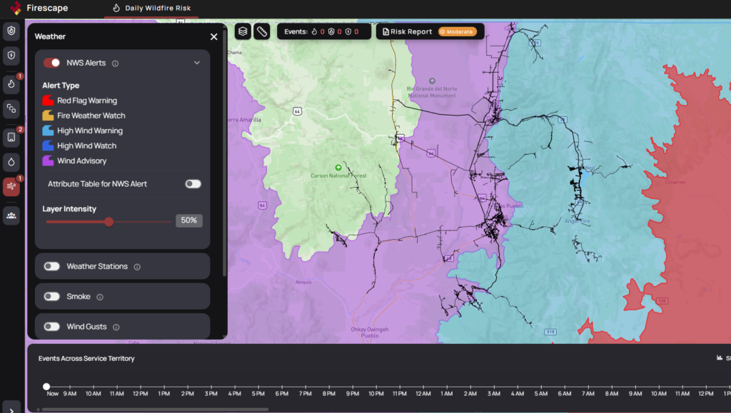
National Weather Service Warnings Affecting 2 HFRAs
Detailed maps and information found at app.firescape.ai.
Wind Advisory
 Impacting: Pilot Region East, and Pilot Region West
 Effective: from February 18 at 11:00 AM to February 18 at 08:00 PM MST
 Last updated: February 18 at 05:13 AM MST
 Impacts: Gusty winds will blow around unsecured objects. Tree limbs may be blown down. Expect strong crosswinds on area roadways.
 Description:* WHAT…Southwest winds 25 to 35 mph with gusts up to 55 mph expected. * WHERE…Portions of western and central New Mexico, including the Albuquerque and Santa Fe metro areas. * WHEN…From 11 AM this morning to 8 PM MST this evening. * IMPACTS…Gusty winds will blow around unsecured objects. Tree limbs may be blown down. Expect strong crosswinds on area roadways. * ADDITIONAL DETAILS…This afternoon and early evening, there is a moderately high probability of snow squalls along and west of the Tusas and Jemez Mountains capable of producing brief periods of near zero visibility, a flash freeze, and a quick inch or two of snow that will make driving treacherous.
High Wind Warning
- Impacting: Pilot Region East
- Effective: from February 18 at 11:00 AM to February 19 at 05:00 AM MST
- Last updated: February 18 at 05:13 AM MST
- Impacts: Damaging winds could blow down trees and power lines. Power outages are possible. Travel will be difficult, especially for high profile vehicles.
- Description:* WHAT…West winds 30 to 40 mph with gusts up to 60 mph expected. * WHERE…Portions of central, east central, north central, northeast, and southeast New Mexico along and just east of the central mountain chain, as well as Guadalupe County. * WHEN…From 11 AM this morning to 5 AM MST Thursday. * IMPACTS…Damaging winds could blow down trees and power lines. Power outages are possible. Travel will be difficult, especially for high profile vehicles. * ADDITIONAL DETAILS…A few inches of snow are forecast in the Sangre de Cristo Mountains this afternoon. Periods of snow and blowing snow will drop visibility below a half mile at times. Snow drifts will reach over 6 inches in spots.